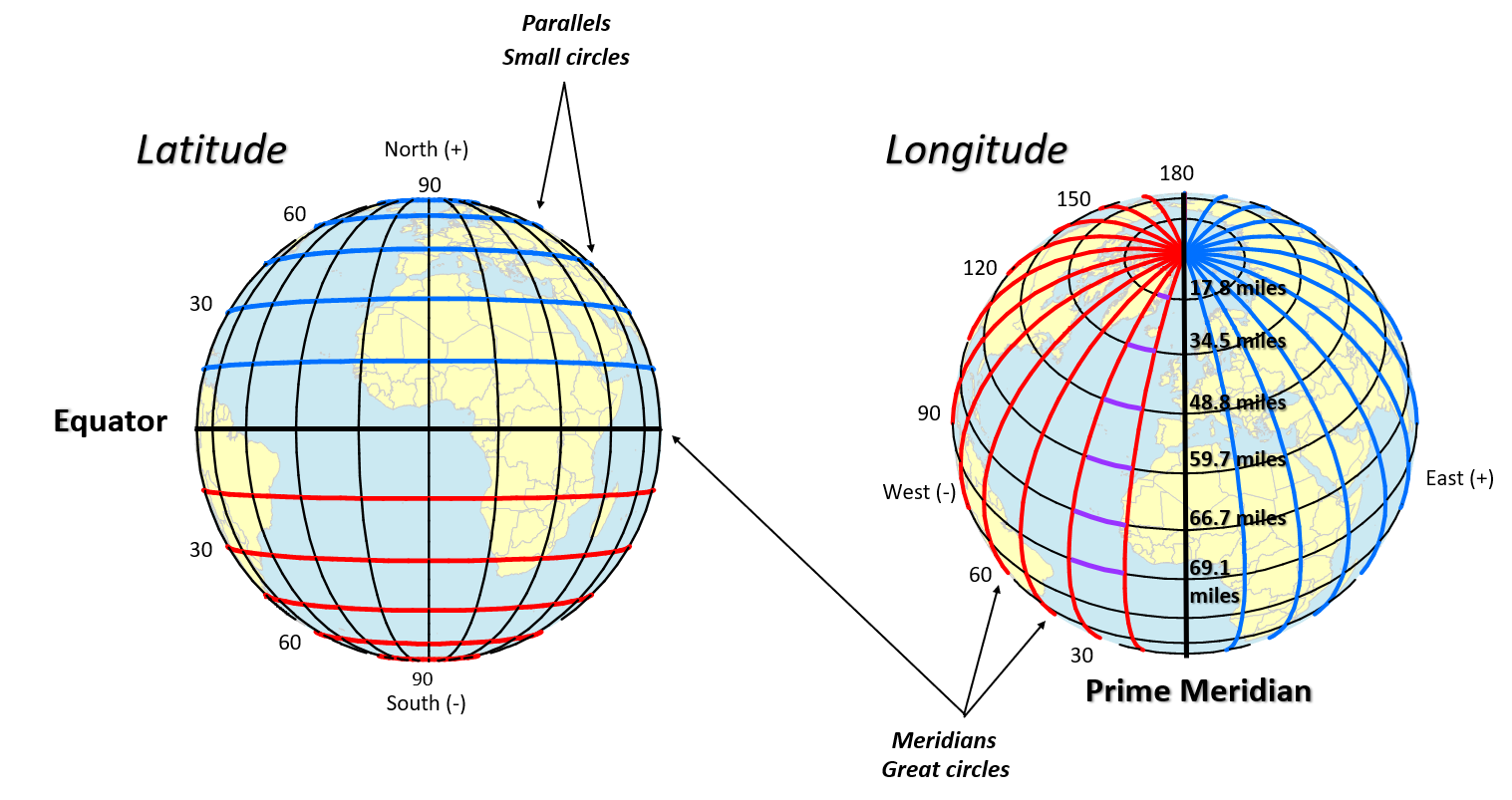
A spatial reference describes where features are located in the real world. You define a spatial reference when creating a geodatabase feature dataset or stand-alone feature class. The spatial reference includes a coordinate system for x-, y-, and z-values. X,y coordinates are georeferenced with a coordinate system. A coordinate system is a reference system used to represent the locations of geographic features, imagery, and observations such as GPS locations within a common geographic framework. Coordinate systems enable geographic datasets to use common locations for integration. There are two common types of coordinate systems used in GIS: geographic and projected. Geographic Coordinate Systems A geographic coordinate system (GCS) uses a three-dimensional spherical surface to define locations on the earth. A GCS is often incorrectly called a datum, but a datum is only one part of a GCS. A GCS includes an angular unit of measure, a prime meridian, and a datum (based on a spheroid). A point is referenced by its longitude and latitude values. Longitude and latitude are angles measured from the earth's center to a point on the earth's surface. The angles often are measured in degrees (or in grads). The following illustration shows the world as a globe with longitude and latitude values. In the spherical system, horizontal lines, or east–west lines, are lines of equal latitude, or parallels. Vertical lines, or north–south lines, are lines of equal longitude, or meridians. These lines encompass the globe and form a gridded network called a graticule. The line of latitude midway between the poles is called the equator. It defines the line of zero latitude. The line of zero longitude is called the prime meridian. For most geographic coordinate systems, the prime meridian is the longitude that passes through Greenwich, England. Other countries use longitude lines that pass through Bern, Bogota, and Paris as prime meridians. The origin of the graticule (0,0) is defined by where the equator and prime meridian intersect. The globe is then divided into four geographical quadrants that are based on compass bearings from the origin. North and south are above and below the equator, and west and east are to the left and right of the prime meridian. Latitude and longitude values are traditionally measured either in decimal degrees or in degrees, minutes, and seconds (DMS). Latitude values are measured relative to the equator and range from -90° at the South Pole to +90° at the North Pole. Longitude values are measured relative to the prime meridian. They range from -180° when traveling west to 180° when traveling east. If the prime meridian is at Greenwich, then Australia, which is south of the equator and east of Greenwich, has positive longitude values and negative latitude values. Projected Coordinate Systems A projected coordinate system is defined on a flat, two-dimensional surface. Unlike a geographic coordinate system, a projected coordinate system has constant lengths, angles, and areas across the two dimensions. A projected coordinate system is always based on a geographic coordinate system that is based on a sphere or spheroid. In a projected coordinate system, locations are identified by x,y coordinates on a grid, with the origin at the center of the grid. Each position has two values that reference it to that central location. One specifies its horizontal position and the other its vertical position. The two values are called the x-coordinate and y-coordinate. Using this notation, the coordinates at the origin are x = 0 and y = 0. On a gridded network of equally spaced horizontal and vertical lines, the horizontal line in the center is called the x-axis and the central vertical line is called the y-axis. Units are consistent and equally spaced across the full range of x and y. Horizontal lines above the origin and vertical lines to the right of the origin have positive values; those below or to the left have negative values. The four quadrants represent the four possible combinations of positive and negative X and Y coordinates. When working with data in a geographic coordinate system, it is sometimes useful to equate the longitude values with the X-axis and the latitude values with the Y-axis. 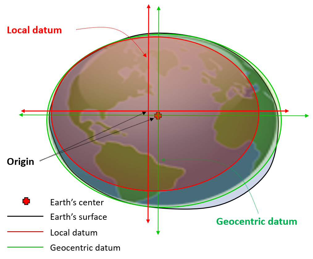 While a spheroid approximates the shape of the earth, a datum defines the position of the spheroid relative to the center of the earth. A datum provides a frame of reference for measuring locations on the surface of the earth. It defines the origin and orientation of latitude and longitude lines. Geocentric datums: In the last 15 years, satellite data has provided geodesists with new measurements to define the best earth-fitting spheroid, which relates coordinates to the earth's center of mass. An earth-centered, or geocentric, datum uses the earth's center of mass as the origin. The most recently developed and widely used datum is WGS 1984. It serves as the framework for locational measurement worldwide. Local datums: A local datum aligns its spheroid to closely fit the earth's surface in a particular area. A point on the surface of the spheroid is matched to a particular position on the surface of the earth. This point is known as the origin point of the datum. The coordinates of the origin point are fixed, and all other points are calculated from it. The coordinate system origin of a local datum is not at the center of the earth. The center of the spheroid of a local datum is offset from the earth's center. NAD 1927 and the European Datum of 1950 (ED 1950) are local datums. NAD 1927 is designed to fit North America reasonably well, while ED 1950 was created for use in Europe. Because a local datum aligns its spheroid so closely to a particular area on the earth's surface, it's not suitable for use outside the area for which it was designed. Common Datum used in the US 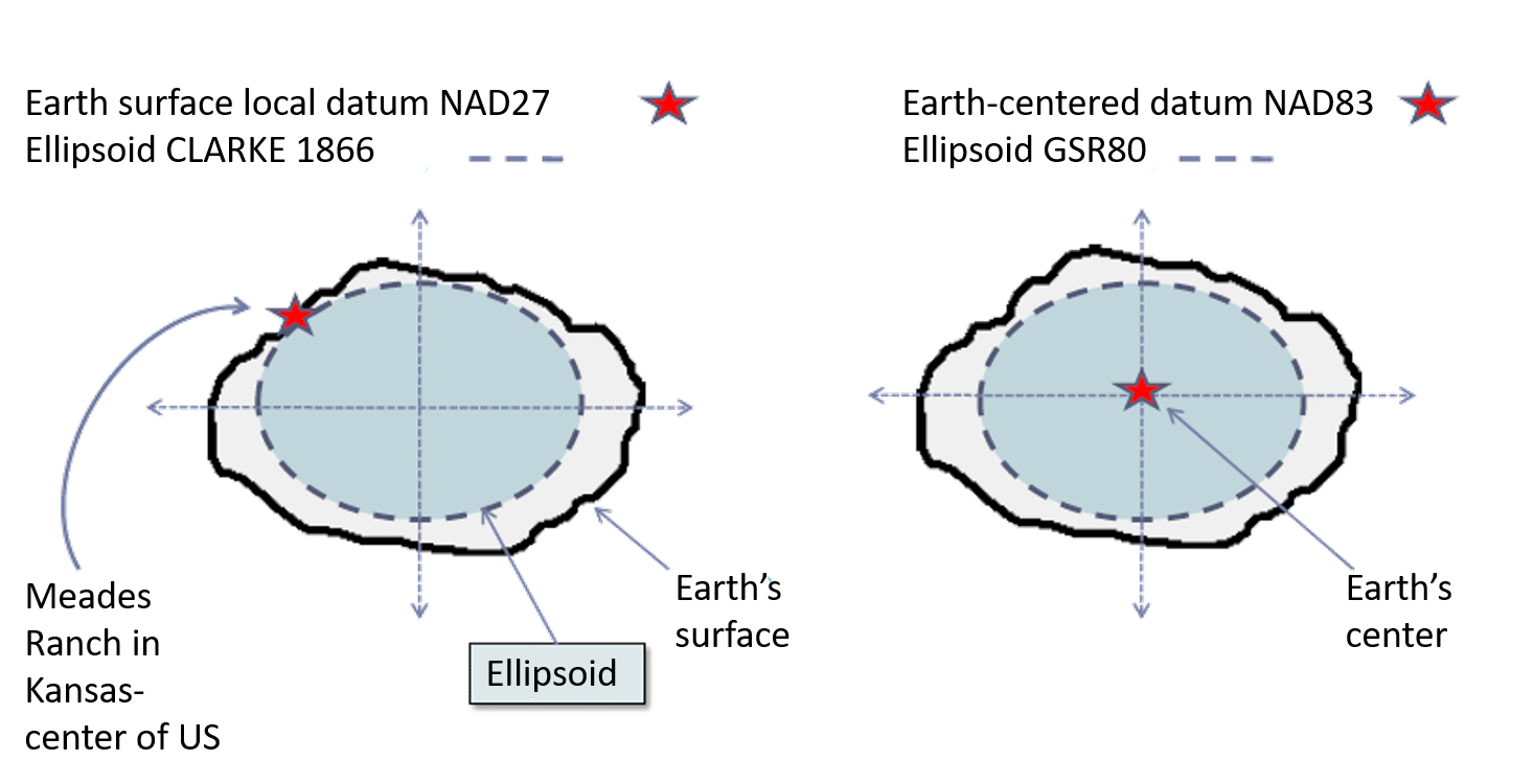 NAD27: 26,000 survey stations NAD27: 26,000 survey stationsNAD 1927 uses the Clarke 1866 spheroid to represent the shape of the earth. The origin of this datum is a point on the earth referred to as Meades Ranch in Kansas. Many NAD 1927 control points were calculated from observations taken in the 1800s. These calculations were done manually and in sections over many years. Therefore, errors varied from station to station. NAD83: 250,000 stations and 2 million distance measurements Many technological advances in surveying and geodesy—electronic theodolites, Global Positioning System (GPS) satellites, Very Long Baseline Interferometry, and Doppler systems—revealed weaknesses in the existing network of control points. Differences became particularly noticeable when linking existing control with newly established surveys. The establishment of a new datum allowed a single datum to cover consistently North America and surrounding areas.The North American Datum of 1983 is based on both earth and satellite observations, using the Geodetic Reference System (GRS) 1980 spheroid. The origin for this datum was the earth's center of mass. This affects the surface location of all longitude–latitude values enough to cause locations of previous control points in North America to shift, sometimes as much as 500 feet compared to NAD 1927. A 10-year multinational effort tied together a network of control points for the United States, Canada, Mexico, Greenland, Central America, and the Caribbean.
|